

We took the road to Moab by driving on the Scenic Byway Road. The landscapes are so beautiful and so different!!! It’s getting hotter and hotter!!!
Where is Capitol Reef National Park located?
Here is the address (but be careful, the G.P.S. doesn’t bring you to the right place, so bring a map with you!)
52 West Headquarters Drive
Torrey, UT 84775
We took this road as we made a stop the last night around Boulder.
This 120 mile (193 km) highway is between Panguitch (intersection with US-89) and Torrey (intersection with Utah State Route 24). It crosses Dixie National Forest, goes by Bryce Canyon National Park, and cuts through much of Grand Staircase-Escalante National Monument before reaching the town of Torrey. The drive to or from Bryce Canyon to Capitol Reef takes about three (3) hours on SR-12.
Some G.P.S. or cell phones might direct travelers to take the South Draw Road from Lower Bowns Campground and Reservoir. It is an unmaintained, high-clearance 4-WD road, not suitable for passenger cars, R.V.s, or inexperienced drivers. South Draw Road is not recommended.
Discover the history behind this place:
From 7,000 – 500 B.C.E. (Before Common Era), Archaic hunters and gatherers migrated through the canyons hunting game that is common now (bighorn sheep, deer, elk, pronghorn).
Capitol Reef National Park protects a rich background of American Indian habitation throughout the Colorado Plateau. Archeologists have discovered information about the indigenous people who lived in the region for nearly 10,000 years, relying on radio-carbon methods and oral traditions from tribal communities.
From 300 – 1300 C.E. (Common Era), the Fremont Culture began farming corn, beans, and squash. Petroglyphs etched in rock walls and painted pictographs remain as sacred remnants of the ancient Indians’ saga.
Fremont and Ancestral Puebloan people began to incorporate farming into their hunter and gatherer lifestyles approximately 2,000 years ago. Petroglyph panels throughout the Park depict ancient art and stories of these people who lived in the area from about 300-1300 Common Era (C.E.). Named for the Fremont River that flows through the Park, evidence now shows that these people lived throughout Utah and adjacent areas of Idaho, Colorado, and Nevada.
The Fremont lived in pit houses (dug into the ground and covered with a brush roof) and natural rock shelters. Their social structure was likely composed of small, loosely organized bands consisting of several families. They were closely tied to nature and flexible, making frequent modifications in their lifeways as social or environmental changes occurred.
For hundreds of years, ethnohistoric nomadic groups such as the Ute, Paiute, and Navajo inhabited the area seasonally. Today, thirty-two tribes have an ongoing association with Capitol Reef through current and historical traditional uses.
Beginning in 1854, several groups of explorers and surveyors made their way through the area that would become Capitol Reef and the surrounding areas.
Pioneers and other settlers arrived in the 1800s, settling in the Fruita Rural Historic District. They planted and nurtured orchards of apples, pears, and peaches.
In 1853, John Charles Fremont passed through Utah and Colorado, attempting to find a northern railroad route to the Pacific Ocean. The expedition was challenging as it was the winter. The explorers were forced to eat their horses before stumbling upon a Mormon settlement. Fremont took care to document their journey, hiring a daguerreotypist, Solomon Nunes Carvalho, a Jewish South Carolinian, to accompany them. Carvalho took nearly 300 daguerreotypes, most of which were unfortunately lost in a fire after the expedition. However, one of the remaining images was identified from the northern district of the Park as the formation “Mom, Pop, and Henry.” Fremont and his men also recorded their encounters with Ute and Southern Paiute Indians.
In 1866, a quasi-military Mormon expedition in pursuit of American Indians penetrated the high valleys to the west. In the 1870s, settlers moved into these valleys, eventually establishing Junction (later renamed Fruita), Clifton, Giles, Elephant, Caineville, Aldridge, and Hanksville. Men from the expeditions of Major John Wesley Powell had also begun to explore the area.
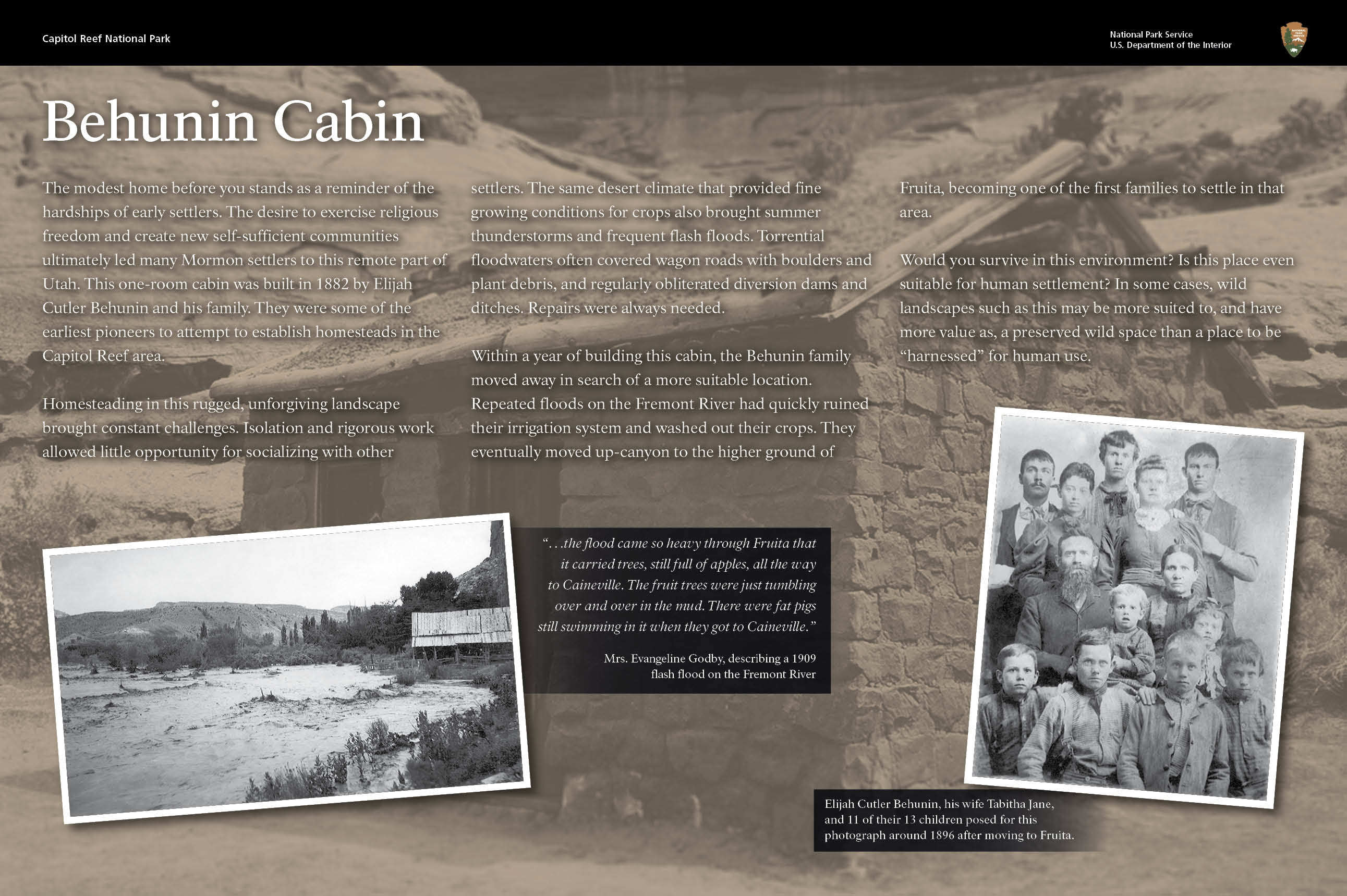
Others followed soon after, and tiny communities sprung up along the life-sustaining Fremont River, including Loa, Fremont, Lyman, Bicknell, and Torrey. In 1880, Nels Johnson moved into Capitol Reef country and staked his homestead in Fruita. Fruita settlers recognized the abundance and accessibility of water and heat that reflected off canyon walls to the soil. Johnson planted the first orchards of apples, peaches, pears, plums, walnut, and almond trees. Later he married Mary Jane Behunin, the daughter of another early Fruita resident, Elijah Cutler Behunin. Behunin built a small cabin that still stands today, along Utah Highway 24.
Behunin led a group of pioneers to clear a wagon trail through Capitol Gorge, which allowed settlers, church officials, miners, outlaws, and others to pass more quickly through the Waterpocket Fold. Behunin also donated land for the Fruita Schoolhouse, which was completed in 1896. His 12-year-old daughter, Nettie, was the school’s first teacher. The school remained open until 1941 when classes were consolidated, and students were bussed to Torrey schools.
No more than ten families were sustained by the fertile flood plain of the Fremont River, and the land changed ownership over the years. Dewey Gifford was one of the area’s last settlers, raising four children with his wife Nell in a two-story house by the Fremont River. Gifford farmed the orchards, worked on a state road crew, and later ran a small motel as visitors came through Capitol Reef National Monument. In their late 60s, Dewey and Nell moved to a new house in Torrey, becoming the last settlers to leave Fruita. Descendants of these earlier settlers still visit Capitol Reef, sharing their history, picking fruit from the orchards, and hiking the paths their ancestors once took.
In 1937, Capitol Reef was established as a National Monument, and a new chapter began in the history of Capitol Reef with the park founders.
Residents (including the Fremont Culture and Mormon pioneers) have long appreciated the Capitol Reef region for its natural beauty and many resources. As early as 1914, entrepreneur (and later Utah Legislature representative) Ephraim Portman Pectol and his brother-in-law (and Utah Legislative Senator) Joseph S. Hickman worked to protect the Capitol Reef area first as a state park, and later as a national monument. Pectol and Hickman valued the natural and cultural they found as they explored the Waterpocket Fold, and wanted to share these wonders with other people. They also hoped tourism could boost the local economy, the way it did when Zion and Bryce Canyon National Parks were established. Pectol and Hickman took photos and wrote stories about “Wayne Wonderland” to promote the region on a statewide level.
Less than a week after the Utah Legislature created a Board of State Park Commissioners, with the goal of establishing new state parks, including “Wayne Wonderland State Park,” Hickman drowned in nearby Fish Lake. With Hickman’s death, much of the statewide support for a park was lost, and not regained until the 1930s. In 1932, the National Park Service sent Yellowstone National Park Superintendent Roger Toll to visit Wayne County, and he reported that “the area seems worthy of future investigation.”
In 1933, with newly elected Pectol in the Utah Legislature, Governor Henry Hooper Blood signed a resolution to the United States Congress detailing proposed boundaries for a park in Wayne County, and the local support behind it. Pectol also wrote to National Park Service Director Horace Albright, encouraging him to consider establishing a monument or Park. Toll once again visited Wayne County, and spent four days with Pectol, exploring the region. Roger Toll reported that the Chimney Rock area (near Utah Highway 24) included “narrow gorges, sandstone cliffs, two natural bridges, archeological remains, pictographs, petrified trees,” and other exciting features.
For a few years, national and state officials went back and forth on proposed boundaries for the future monument and a name. In 1935, Pectol and Toll settled on the name Capitol Reef National Monument, since “Wayne Wonderland” indicated a much more locally-focused area.
In 1937, all the promotional photographs, stories, and determination paid off when President Franklin D. Roosevelt set aside 37,711 acres as Capitol Reef National Monument. It comprised an area extending about two miles north of present Utah Highway 24 and about ten miles south, just past Capitol Gorge.
Throughout, women have played an essential role in the story of Capitol Reef.
Ellen Powell Thompson explored alongside her husband and others as they mapped this area in 1871. Pioneer families started to arrive in the late 1800’s, developing the community of Fruita. Later residents included artists, businesswomen, and National Park Service, staff.
What did we see there?
We saw the Blacksmith Shop, the Gifford House, where you can buy and taste homemade pies, the Fruita Schoolhouse, the Petroglyph Panel, and a little hiking to see the arch: Hickman Bridge.
The stories are written in the stones:
There are many meanings to the markings applied to rock walls at various places in Capitol Reef and across the Southwest. Most occurrences of petroglyphs and pictographs in Capitol Reef are attributed to the Hisatsanom (The Fremont Culture) and were created between about 300 to 1 300 C.F. Some are older still and represent people whom archeologist refer to as Desert Archaic. Petroglyps and pictographs were created using stone tools and mineral, and plant derived pigments. This distinctive style is found primarily throughout Utah and contrats somewhat with markings in other parts of the Southwest.
The modern day tribes with the closest association to petroglyphs at Capitol Reef are the Hopi Tribe and Pueblo of Zuni.
The Hopi and Zuni say the markings confirm the presence of their ancestors in Capitol Reef. The stories present detailed information regarding geography, demography, economy and religion. They describe activities common to daily life, maps and journeys, clan symbols, deities, animals that were hunted, calendars and other features. Other tribes associated with Capitol Reef say the markings may be considered as libraries that speak to American Indians about past events, legends, journeys and genealogy, among other topics.
Why I loved this Park?
It is not known so well National Park, and it was nice to feel alone since the Park entrance. The day we went there, it was hot, but we did find a few places with fruit trees so we could just hang out behind them and enjoy some pies!
This Park was very different from Zion and Bryce, but the story is written not only in the rocks but also the people who were living there (a not so long time ago)
Enjoy this Park!


